Gateway to the Grand

Having gotten just a little glimpse of the Colorado River yesterday, I was eager to get out and experience her a bit more today. I researched a couple trails south of Lees Ferry and the Paria Canyon convergence. The drive down from Page was absolutely epic, dropping 2000 ft. in a matter of minutes. The character of the rock changed considerably from the rounded, orange lines of Glen Canyon to the ruddy, towering walls of a canyon I am much more familiar with.
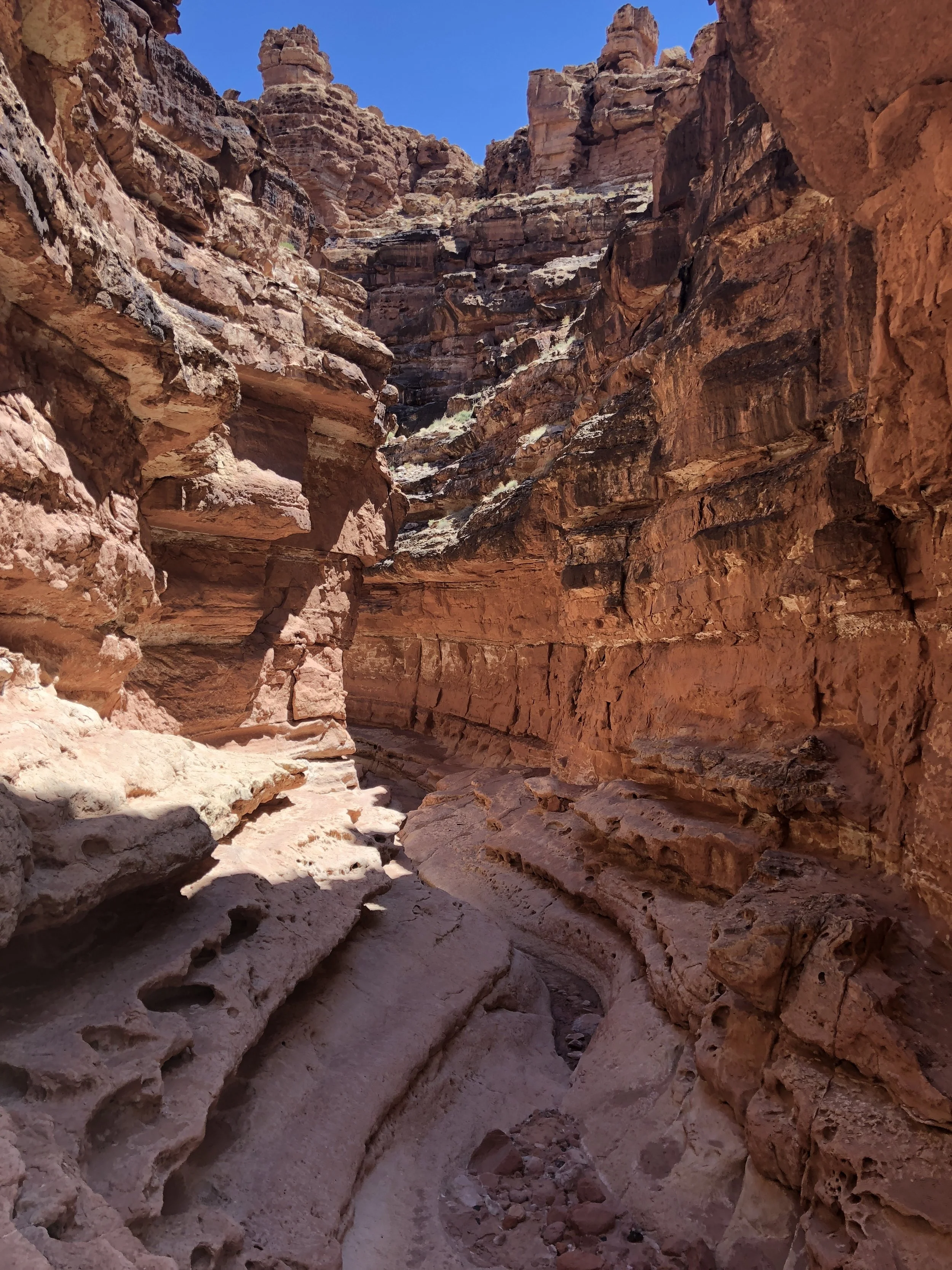
In fact, our first hike, although not terribly lengthy, would begin in Glen Canyon National Recreation Area, and end in the uppermost extremity of Grand Canyon National Park, if all went as planned. It was shaping up to be a blazing hot day, but this was going to be a true canyon hike, shaded by high walls on either side. Cathedral Wash, named for the impressive promontory marking its source, would get us all the way down to the Colorado, but not without some really fun obstacles to sort out along the way!
Every trip report I read had a common theme: Stay right! We came to several minor obstacles, and did just that, but in almost every case there were multiple solutions. Finally, we reached the one everyone was talking about: a 30-ft. amphitheater-shaped waterfall, dry except for a small pool at the bottom. I located a system of 4- and 5-ft. ledges to the right that were fairly well marked, lent Mom a shoulder for a couple of them, and we were on our way. The 1.5-mile trail down took quite a while as we had to backtrack rather frequently to find the way around drop-offs and occasional pools, but it was so much fun I didn’t care. Truly my kind of puzzle.
Toward the bottom, the walls got higher and the boulders blocking the way got much larger. This place must be terrifying in a rainstorm! I can’t tell you how excited I got when we first heard the roaring of the river in the distance. It had been over two years since my last opportunity to stick my feet in that magical green water, and I could hardly wait. We spent nearly half an hour perched on the shore numbing our feet in the cold before heading back, which was much easier than the trip down.


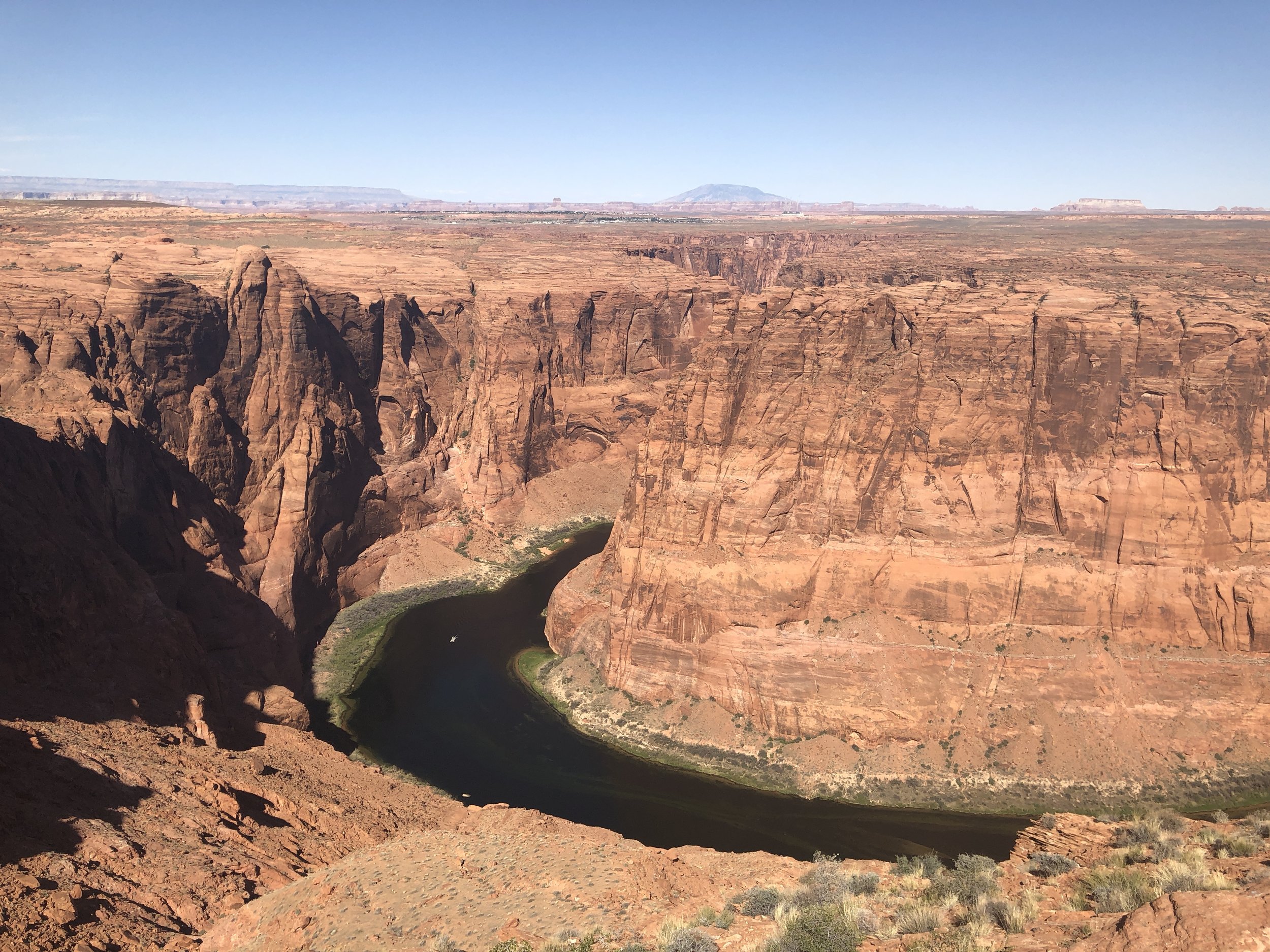
We grabbed a quick lunch at the little diner in Marble Canyon (green chile stew, Navajo flatbread, and coffee for me, hell yes) before heading all the way up to Lees Ferry for hike number 2. That place was positively bustling when we got there, as it is a major point of departure for Grand Canyon rafting trips. I had been really intrigued by a particular trail I located on Google maps but was a little baffled by many of the trip reports I read. The Spencer Trail starts as a riverside stroll but quickly switchbacks its way up the canyon wall to the narrow point of another horseshoe in the Colorado. The main complaints seemed to be about exposure and a lack of trail maintenance. Um...sounds perfect to me!
Mom set off with me but decided to sit this one out once the gain started to pick up. That first hike had taken a toll. I could immediately tell that sun exposure was going to be a constant on this one. After a few days of pretty gentle hiking, I was excited to get into some steep stuff. Every once in a while, I find the perfect trail for the moment, and the Spencer Trail was just that. Within no time, I was waking up my lungs, busting the hell out of my quads, and sweating my ass off. In other words: heaven. This trail was so rough and fun, and the first two-thirds of the way up the wall were relentless. The trail levels out for a bit to circumvent a couple of large rock formations, and at this point I looked up and noticed the amazing the views down to the river and over to Paria Canyon. Wow. This really is the beginning of the Grand Canyon!

I pushed hard up the last ascent, and quickly checked to see how long it had taken me to get to the top. Forty-five minutes. Couldn’t be; AllTrails says the hike is 1.9 miles up and over 1600 ft., which just doesn’t line up with my normal formula. But I did feel a little possessed, so who knows!?!
I stopped a while to rehydrate and eat some of these amazing Jelly Belly caffeinated Sport Beans we discovered on this trip (yes, I realize how ridiculous that sounds, but those of you who know me well will surely recognize its my ideal food). Then I ventured up and over the gentle rise to see the other side. Craziness! Looking north, I could see all the way back to Lake Powell, and it really looked like a different planet. This is the perfect example of why I love this area so much. Geology is completely fascinating to me, and I will never tire of learning about history from the gorgeous shapes and colors of these rocks.
After venturing back to the south side of the ridge and spending who knows how long trying to get the perfect picture of a very charming lizard, I set off back down the switchbacks. This hike had energized me so much that I ran the flatter segments and sprinted out the final riverside trail. I have so many more things I’d love to see in this area, but tonight we’ll be pushing as far east in the RV as daylight will allow.


The stats
Cathedral Wash:
Distance: 3.0 miles
Gain: 337 ft.
Spencer Trail:
Distance: 3.8 miles
Gain: 1,614 ft.
* Sorry - couldn’t resist throwing in that shot of the Puckster eagerly waiting to hit the road in Page.